- Body
Erosion/Deposition Components of Riparian Health:
- Understanding a Channels Ability to Dissipate Energy
- Point Bars
- Lateral Stability in Riparian Areas
- Vertical Stability in Riparian Areas
- Understanding if the Channel is in Balance with the Soil and Water Being Supplied
Understanding a Channels Ability to Dissipate Energy Dissipating Energy - a Channel's Job
While the primary function of riparian channels is to convey water and sediment, they also dissipate stream energies. Energies can be dissipated within the channel through boulders or large wood, or by sinuosity. If flows and energies are high enough, then floodplains help dissipate the energies, especially in wide valleys. Floodplains act as overflow buffers and serve a critical function in mitigating the downstream impacts of floods. Floodplains comprise the area adjacent to channels over which out-of-bank flows are diffused. These areas reduce the energy by spreading out the high flows. If floodplains are vegetated with riparian plants, then the vegetation will further absorb energies and slow the flows.
Different Channel Types Mean Different Ways to Dissipate Energy. Channel characteristics vary by channel type which must be identified in order to evaluate streams correctly, and understand the ways in which energies are dissipated. For example, a B2 channel type is moderately entrenched, typically located in or on coarse alluvium, and has a limited floodplain. This channel type has channel characteristics of boulders and small cobbles as well as some floodplain for expansion and often woody riparian vegetation to dissipate stream energy. On the other hand, a C4 channel type is a slightly entrenched and gravel-dominated stream, which has to have access to a floodplain and channel characteristics such as backwater areas, oxbows, and overflow channels along with riparian vegetation to dissipate stream energy.
Channels which have lost those characteristics that help them to dissipate energy are quickly degraded.
Warning Signs. Some floodplain and channel characteristics warning signs to look for that may indicate declining health or “unraveling” of riparian areas include:
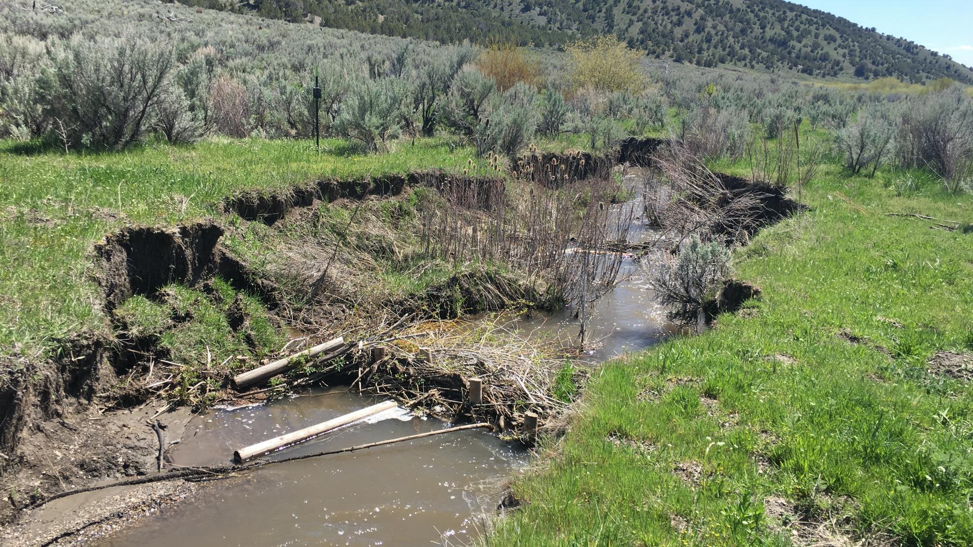
- Low sinuosity – In those channel types which use sinuosity to dissipate energy, a loss or lack of sinuosity indicates that the channel is not dissipating energy. The lack of sinuosity often manifests itself in other ways, such as downcutting and excess bank shearing.
- Lack of large woody debris – In those channel types where large woody debris is necessary for disippating energy, a lack of woody debris would cause an increase of energy which may lead to downcutting or widening of the stream. Woody debris also creates pools and dams that capture bedload sediment to maintain bed elevation.
- Downcutting – when a disturbance causes the stream to increase its velocity, one way it accounts for the extra energy is to erode away the channel bottom. An incised channel is one in which the average flood--of the size and intensity which occurs roughly every one to three years--is unable to "access its floodplain" by overflowing its streambanks. As the channel cuts downward, the groundwater table is lowered.
- Channel Widening – by spreading the water out in a wider channel, energy can be diffused. Unfortunately, this widening raises temperatures above thresholds for fish and reduces available shading. Overwide channels do not transport their bedload sediment adequately and aggradation can cause the channel to move.
Point Bars
The Formation and Maintenance of Point Bars. The formation and extension of point bars into channels is a natural depositional process for some channel types. Point bars are formed when the higher velocity flows on the outside of meander bends erode the bank, and then deposit that sediment on the inside of a meander bed where velocities are lower. It is crucial that vegetation colonizes these deposits as they extend over time to maintain a balance. Point bars forming and then gaining finer sediments stabilized by vegetation is how folldplains form in these channel types. If vegetation cannot maintain a balance, energies during high flows accelerate erosion, which affects sinuosity, gradient, and access to the floodplain resulting in the degradation of the riparian-wetland area. The vegetation present needs to be riparian-wetland plants that have root masses capable of withstanding high-flow events. Point bars are most common in Rosgen's B and C channel types.
Warning Signs. Some warning signs that sediment is not being captured on point bars, which may indicate declining health or “unraveling” of riparian areas include:
- Point bars without vegetation. A lack of vegetation on point bars (given that it has had sufficient time to establish), may not maintain a consistent channel pattern and this can increase stream slope or gradient, causing downcutting and increased sediment loads.
- Point bars are repopulating with non-riparian vegetation. If point bars are revegetating with plants that don’t have the root masses capable of holding soils, further erosion could occur.
Understanding Lateral Stability in Riparian Areas
What is Lateral Stream Movement? Streams located within non-confining landforms are constantly in the process of moving back and forth across the valley floor. This lateral stream movement is a natural process and enables the stream to slow its velocity. It has been defined as meandering or snaking through the landscape, patterned after how a snake moves over land. When this movement is excessive, it can have serious impact on the overall function of a riparian wetland area, limiting its ability to dissipate energies.
Lateral Stream Movement is a Natural Process. Lateral movement of stream channels is a natural process in wide gently sloping valleys. Because sinuosity and lateral stream movement are a function of landscape setting, lateral movement is strongly related to how the stream maintains balance with its landform. Lateral movement occurs through bank erosion, and its rate is influenced by many factors, especially stream type, nature of bank material, and kinds and amounts of vegetation on the streambank, as well as how point bars are functioning within the system.
Bank erosion must be evaluated relative to stream type, particularly as a stream type manifests itself in the bank material sizes present at a site. For example, a meandering riffle-pool stream channel likely will exhibit higher bank erosion rates in areas of sandy material than in areas where silts and clays provide some cohesiveness to the bank. Thus, “natural” rates of channel migration will vary by stream type and material. Streams or rivers with very stable banks and well rooted vegetation become deep and narrow, highly sinuous, and they flood often. If streams lose bank stability and become wider as they move faster, their length shortens as they become straighter. This can also happen if sediment supply is increased. Some streams naturally occur in areas with sandy or gravelly sediment or higher sediment loads and are like this naturally. When meandering streams lose too much bank vegetation and stability or receive too much sediment, they can become braided. Braided channels move rapidly in each high flow. Their multiple channels split apart and come back together. In some settings, a braided channel is natural and in others it represents unnatural conditions.
Warning Signs. Some warning signs that indicate that sediment is not being captured on point bars, and that the system may be declining or “unraveling” include:
- Widening of the Stream Channel - On a naturally meandering channel, new point bars will be extending into the channel on the inside of curves at about the same rate the banks on the outside of curves are eroding away. Thus, the width of the channel remains constant over time. In contrast, a destabilizing laterally cutting channel becomes wider over time.
- An Active Channel that Relocates with each Event - An active channel within a riparian area relocates itself with every high-flow event – this is a sign that the stream isn’t laterally stable.
- High Amounts of Bank Erosion, especially on the outside of curves – this can be remedied some by the establishment of vegetation with the root masses capable of holding the banks during high-flow events.
- High banks and infrequent flooding - If the banks are unstable and do not revegetate because they have become dehydrated, the banks may be eroding because of channel incision, which could be due to too much straightening or lack of piontbar vegetation or sediment.
Some channel types are limited to lateral movement by existing landforms such as bedrock, and should be considered laterally stable.
Understanding Vertical Stability in Riparian Areas
Channels Downcut over Time. Stream channels transport water, sediment, and other materials out of the watershed, thus reducing the overall elevation of the landscape, including the valley bottom. This channel lowering, although part of the natural cycle of landscape evolution, usually occurs at rates that are detectable only over very long periods of time (i.e., hundreds of years or more). Occasionally, natural disturbances or human activities are significant enough to produce rapid vertical adjustments of a channel or channel network that are measurable (several feet or more) in relatively short periods of time (decades or less). These rapid vertical adjustments are known as downcuts (or incisement) or headcuts.
Rapid Downcutting is an Indicator of a Problem. Downcutting of a channel is an indication a riparian system may not be functioning properly. After natural or human disturbance to a system, downcutting occurs when this disturbance causes the stream to increase its velocity and erode away the channel bottom. An incised channel is one in which the average flood--of the size and intensity which occurs roughly every one to three years--is unable to "access its floodplain" by overflowing its streambanks. As the channel cuts downward, the groundwater table is lowered. Consequently, water-loving plants are isolated on the old floodplain and streambanks, and may no longer get the moisture they need.
Determine the Cause. If vertical instability of the stream is suspected, it may be useful to determine if downcuts are the result of local conditions such as a breaching of a beaver damn on site, or if there is something larger happening within the watershed that might be causing the instability. It is important to note that it is often difficult to differentiate between local and watershed-wide processes without extending the investigation upstream and downstream of the site in question.
The Process of Restabilizing. During basinwide adjustments, there are a series of stages of channel evolution that the channel will undergo. For example, a well-vegetated, healthy stream which frequently uses its floodplain often will undergo bed-level lowering following a perturbation (such as a breach of a beaver dam). This downcutting usually results from excess stream power in the disturbed reach. Bed-level lowering eventually leads to oversteepening of the banks, and when critical bank heights are exceeded, banks collapse into the channel, causing mass wasting, which leads to channel widening. As mass wasting and channel widening proceed upstream, an aggradation phase follows in which a new low-flow channel begins to form in the sediment deposits at the new lower level. Upper banks may continue to be unstable at this time. The final stage of evolution is the development of a channel within the deposited alluvium with dimensions and capacity similar to the predisturbance channel. The new channel is usually lower than the predisturbance channel, and the old floodplain now functions primarily as a terrace. Where vertical channel adjustments are systemwide, this sequence of evolution usually manifests itself longitudinally along the stream profile and often along the tributaries as well in the form of headcuts moving up through the stream system.
Warning Signs. Some warning signs in regards to vertical stability to look for that may be indicative of declining health or “unraveling” of riparian areas include:
- Downcuts - streambanks that are more than twice as high as normal for the size of the normal stream channel in that geomorphic setting.
- Headcuts - Waterfalls or nick points in erodible material cut toward the headwaters of the stream. Their head cutting generally is not stopped for long by vegetation alone unless the amount of water is very little and roots go under the channel. Even then the turbulence from the fall of water into the pool below often causes scour and headcutting.
- Stream Bank Shearing and Mass Wasting - once banks become too high, they dehydrate and weaker rooted plants are no longer able to provide bank stability.
An Example of Recovery. A common situation in the West is shown in this figure. Here past events created an incised channel and changed the relationship of the stream to its surrounding landscape. The water can no longer get near the top of the old streambanks. As a result, vegetation on top of these old streambanks has become an upland community. However, the stream apparently has ceased downcutting, and a new riparian area is developing in the bottom of the incised channel. The stream can reach this new floodplain. The vegetation established along the new streambanks and on the new floodplain is performing the functions of a riparian community.
Understanding if the Channel is in Balance with the Soil and Water Being Supplied
The Balance Between the Channel and the Water and Sediment. Viewed over very long periods of time and under relatively stable climate regimes, undisturbed channels and their floodplains exist in a state of relative equilibrium. Streams transport water and sediment out of a watershed, and channels are constantly adjusting to account for changes in the water and sediment. These erosion and deposition processes generally offset each other. Excessive erosion or deposition indicates that this process is out of balance. In order to determine if the stream is in balance, the following questions must be answered
Are sinuosity, width/depth ratio, and gradient in balance with the channel? Could the uplands be contributing to riparian degradation? Are floodplains and channel characteristics able to dissipate energy? Is the channel vertically stable?
Warning Signs. Some warning signs that might indicate that a stream is out of balance with the water and sediment load, that may indicate declining health or “unraveling” of riparian areas include:
- Braided Channels - Natural channels can be classified as either single thread or braided channels. While some braided channels are natural, most braided channels reflect unnaturally high sediment loads, and indicate the process is out of balance. (For more information on naturally braided channels, refer to the Rosgen Classification Method).
- Mid-Channel Bars – Excessive sediments being transported through the system can form mid-channel bars that indicate excessive erosion upstream. Examples of what might cause this include runoff after a wildfire, excess road density or poor road design, or stream incision farther up the watershed.
- Unstable Streambanks – An increase in the amount of water flowing through the system will require the channel to adjust to the higher flow and the energy that is associated with it. The increase in flow requires the channel to widen to enable room for the increased discharge and energy. Sheared banks are the most common evidence of widening of the channel. One example of a channel needing this type of adjustment would be a transmountain diversion that takes water from one watershed and puts it in the stream of another. This generally requires a change in both channels. The dewatered channel may eventually lack channel capacity for undiverted bigger flows.
- Fine materials on the channel bottom - The presence of fine sediments (silts, clays and decomposing organic material) on the channel bottom may indicate that not enough water is running through the system or that there is too much sediment entering the stream. This is especially the case when sediments remain in place through one or more high flow events. Fine sediments cover fish spawning areas as well as change the composition of macro-invertebrates (bugs) in the stream, which also affects fish populations.
Further Reading
Surber, G., B. Ehrhart. 1998. Stream and Riparian Areas Management: A Home Study Course for Managers. Montana State Extension Service.
USDI Bureau of Land Management. 1998. Riparian Area Management: A User Guide to Assessing Proper Functioning Condition and the Supporting Science for Lotic Areas. Technical Reference TR 1737-15. 124 pp.
Zaimes G.N. (editor). Understanding Arizona’s Riparian Areas. University of Arizona Cooperative Extension, Publication # az1432.