- Body
Hydrologic Components of Riparian Health:
- The Function of Floodplains
- The Role of Beavers in Riparian Areas
- Is the Channel in Balance with the Landscape?
- Riparian Areas and Water Storage
- How Uplands Contribute to Riparian Health
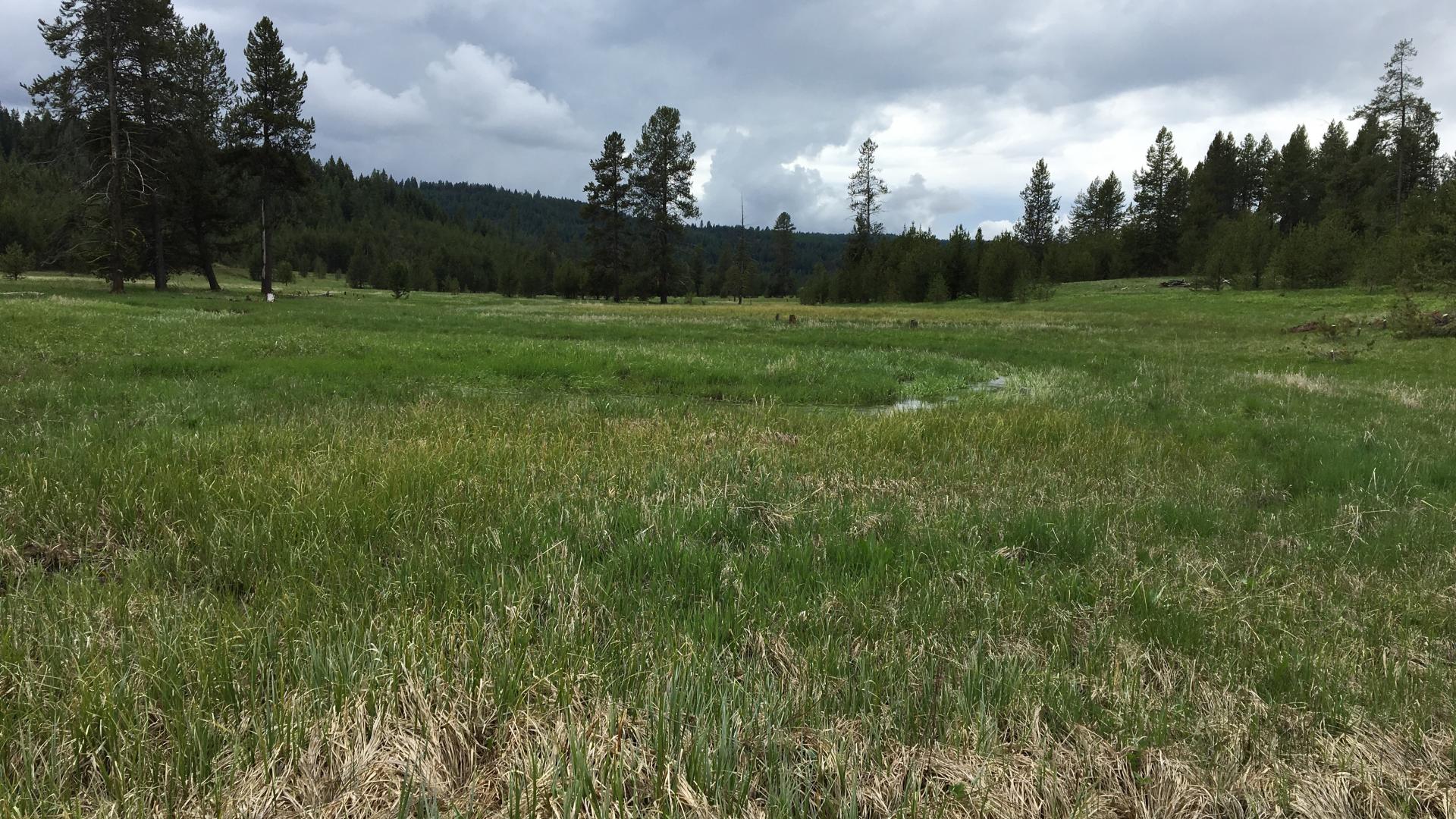
The Function of Floodplains
What is a Floodplain? Schmudde provides three definitions of floodplain: 1) Topographically, it is flat and lies adjacent to a stream. 2) Geomorphically, it is a land form composed primarily of unconsolidated depositional material, or sediments, derived from the stream. 3) Hydrologically, it is a land form subject to periodic flooding by the stream.
Floodplains develop over time as the result of flood inundations. The water moving over a floodplain travels at a lower velocity than the channel flow, and as flow velocity decreases, sediment is deposited. Over time, these deposits of nutrient-rich sediment are built up in layers. The sediment also brings nutrients to the riparian vegetation which is growing upon it.
Function of Floodplains. Schmudde provides a good summary of the functional purpose of the floodplain: “Thus, the floodplain is seen as an integral part of the stream system and the adjustment mechanism needed to meet the requirement of discharge and load imposed by the basin it serves.”
When evaluating a riparian area, it is important to determine if frequent floodflows are capable of spreading out on a floodplain adjacent to the stream thereby providing for energy dissipation, sediment deposition, and periodic flooding of vegetation. Stream systems that are not highly confined generally support a floodplain landform that is flat and adjacent to the stream. However, if the channel is downcut and floodflows can no longer access the floodplain, it no longer provides those important hydrologic functions.
The floodplain provides the additional capacity for the stream system to transport and store water and sediment. The magnitude and significance of the additional capacity depends on the spatial extent of the floodplain along with basin and stream system characteristics. Vegetation often is an important player in the efficiency and longevity of floodplain function. Periodic flooding of the floodplain is often necessary to promote and sustain riparian vegetation and therefore is a key factor in determining the functional condition of the riparian system.
Understanding Bankfull. The floodplain is functional if it is normally connected to the stream at the bankfull discharge point of the channel. Wolman and Leopold (1957) suggest there is an annual flood that normally reaches the floodplain every year or so. Gebhardt, et al., (1989) call this area of inundation the “active floodplain” to distinguish floodplain activity form floodplain inactivity. Thus, an active floodplain would see some inundation every year or so, and the spatial extent of the inundation would increase over the floodplain as the magnitude of the flood increases. In other words, the larger the flood, the more floodplain will be used. The loss or reduction in the ability of the floodplain to dissipate energy and transport water and sediment are key factors in contributing to loss of functionality.
Evaluation of bankfull discharge is key in determining whether the topographic floodplain feature is connected to the stream. Water enters the floodplain when flows begin to exceed bankfull discharge. Bankfull discharge is significant for riparian resource management in that it represents a measure of interaction between the stream and it's adjacent valley bottom; thus, it strongly influences the geomorphic and biological characteristics of the riparian environment. Bankfull discharge on the majority of streams in the world has a recurrence interval between one and three years; one and a half years is considered a reasonable average. Hence, the floodplain will be accessed in relatively frequent events.
Bankfull stage, or elevation of water surface, can be identified in the field through several observable features: top of point bar, changes in vegetation, topographic break in slope, change in size, staining, or color of substrate material, and change in the nature and amount of debris deposits (Leopold, 1994)
It is best to have more than one indicator present, as just one -- for example, vegetation -- can be indicative of more short-term events than the channel-forming flows.
Bankfull discharge for a channel may be determined through the use of one or more surveyed cross-sections and a number of hydraulic models. These are best done by trained professionals who use the data that are collected from them. Your local Extension Agent can help you find a trained person.
Warning Signs. Some warning signs that the floodplain is not being inundated, which may be indicative of declining health or “unraveling” of riparian areas include:
- Oversized Channels. Channels have widened to the point that the floodplain is not accessed fairly frequently.
- Downcut/Incised Channels. Channels that have downcut are incapable of accessing their floodplains and will begin the process of establishing a new floodplain at it's lower levels, if possible.
Exceptions to the Rules. There are situations in which floods do not reach the floodplain due to flows being regulated -- either through reservoirs or diversions. The regulation of flow keeps the stream from having to dissipate energies on a floodplain regularly.
References
- Gebhardt, K., C. Bohn, S. Jensen, W.S. Platts. 1989. Use of hydrology in riparian classification. In Practical Approaches to Riparian Resource Management – An Educational Workshop. Bureau of Land Management. Billings, MT. pp. 53-59.
- Leopold, L.B. 1994. A View of the River. Harvard University Press, Cambridge, Massachusetts. 298 pp.
- Schmudde, T.H. 1968. Flood plain. In The Encyclopedia of Geomorphology, edited by Fairbridge, R.W. Reinhold Book Corporation, NY. Pp. 359-362
- Wolman, M.G. and L.B. Leopold, 1957. River floodplains: some observations on their formation. USGS Professional Paper 282-C.
The Role of Beavers in Riparian Areas
Benefits of Beaver. Beavers are key agents of riparian-wetland succession because their dams act as hydrologic modifiers. When a beaver dam is constructed, a flowing stream can be changed to a pond overnight. This in turn can lead to aggradation of the channel, establishment of floodplains, and raising groundwater levels. Elevated water levels also help to keep water in areas that would be otherwise dry during summer months and also during times of drought. This helps to sustain plant and animal life. The key to whether or not a beaver dam is beneficial is its stability. Beaver dams built with the correct, stabilizing woody vegetation, where there is enough additional woody vegetation to maintain the dam once built, are considered stable. Some beavers, known as “mudders,” also pack their dams with mud. The mudders’ construction technique creates a better basis for vegetation to capture a dam, thus helping to stabilize it.
Disadvantages of Beaver. Although beaver dams can be a benefit, they can also be a hazard. Beaver dams that are not stable unleash tremendous energies when they fail that often results in degradation and stream adjustments, including channel widening, lowering, and lateral migration. For this reason, it is important to note when evaluating riparian health whether beaver dams that are present are being actively maintained. A dam that isn't being maintained, or has not used mud in the construction, or is not captured by vegetation will breach at some point.
Warning Signs. Poorly constructed beaver dams, or those made from the wrong materials, such as the sagebrush dam in the above picture, will breach easily and can lead to degradation of the current channel. Some warning signs that a beaver dam is unstable and may lead to a breach and subsequent decline in health of the riparian area include:
- Lack of sufficient woody vegetation. Is there sufficient woody vegetation present for dam construction and maintenance? If not, there will be little vegetation to maintain the dam once built and may cause beaver to abandon the dam.
- Beaver dams with breaks or leaks. This may be a sign that a breach of the dam is forthcoming.
- Beaver dams which lack captured vegetation. Captured vegetation growing within and among a beaver dam helps to stabilize it and prevent breaching.
References
- American Geophysical Union. 2006. Beaver Dams Create Healthy Downstream Ecosystems. Science Daily: June 6. www.sciencedaily.com/releases/2006/06/060605120417.htm.
- University of Alberta. 2008. Busy Beavers Can Help Ease Drought. Science Daily: February 26. www.sciencedaily.com/releases/2008/02/080220130511.htm.
- USDI Bureau of Land Management. 1998. Riparian Area Management: A User Guide to Assessing Proper Functioning Condition and the Supporting Science for Lotic Areas. Technical Reference TR 1737-15. 124 pp. www.blm.gov/or/programs/nrst/index.php
Is the Channel in Balanced with the Landscape?
Streams and their Landscapes - Understanding the Connection. The way a stream appears and the way water flows through the system is related to the landscape within which it exists. Streams in narrow, high mountain valleys are often steep with little sinuosity. Energies are dissipated with step/pools and with large boulders and debris within the channel. Streams that occur in wide valleys tend to move slowly, have only gradual slopes, and use sinuosity to further slow down and control the flow. Thus, the attributes of sinuosity, width/depth ratio, and gradient all play an important and related role in how well a stream dissipates energy. The landform in which a stream occurs will determine what the sinuosity, width/depth ratio, and gradient should be. To be in balance, a stream's attributes should match its landscape. If one of these attributes is out of balance, it often leads to the others being out of balance as well. For example, when there is a decrease in sinuosity, it results in a higher stream gradient, which increases velocities. Increased velocities accelerate erosion, which alters sinuosity, gradient, floodplain access and width/depth ratios.
Determining Balance. Determining a stream’s balance requires classification of stream length. Channel classification tools such as Rosgen’s (SEE ROSGENS) describe a range of characteristics for specific channel types and make it easier to understand this balance. Classifying the stream will also help to describe the stream’s position in the landscape and the expected range of variability for composition of bed and bank materials and for parameters related to channel size, shape, and pattern. Classification of the stream reach under consideration -- as well as adjacent reaches in both upstream and downstream directions -- and evaluation of recent channel evolution will provide a great deal of information for determining if the sinuosity, width/depth ratio and gradient of a stream are in balance with the landscape settings.
Warning Signs. Some warning signs that sinuosity, width/depth ratio, and gradient are out of balance, indicative of declining health or unraveling riparian areas include:
Stream is becoming wider and shallower - Stream channels get wider and shallower when something causes the banks to break down or when the amount of sediment in the channel exceeds the capacity of the water to move it through the system. An aggrading channel may find an alternative route and suddenly switch locations. Also, as the stream becomes shallower, stream temperatures may rise, which can increase bacteria, algae, and other organisms that respond to sunlight penetration and that may reduce water quality. Stream temperatures which exceed tolerance levels also adversely affect fish habitat. These levels differ from species to species.
Sinuosity is reduced, channel is straightening – Sinuosity differs depending on the type of stream that is being dealt with. If sinuosity is out of balance, water velocity is increased. This can lead to downcutting and/or bank shearing. Bank shearing may be the channel trying to widen to re-establish its sinuosity.
References
- Rosgen, Dave. 1996. Applied River Morphology. Wildland Hydrology, Pagosa Springs, CO.http://www.wildlandhydrology.com/
- Surber, G., B. Ehrhart. 1998. Stream and Riparian Areas Management: A Home Study Course for Managers. Montana State Extension Service. Information also available athttp://www.animalrangeextension.montana.edu/riparianmgt/index.htm
- USDI Bureau of Land Management. 1998. Riparian Area Management: A User Guide to Assessing Proper Functioning Condition and the Supporting Science for Lotic Areas. Technical Reference TR 1737-15. 124 pp. More Information available at: http://www.blm.gov/or/programs/nrst/index.php
Riparian Areas and Water Storage
Storing Water in a Riparian Area. A healthy riparian area includes much more than just the channel in which the water flows and the vegetation on the banks near it. Healthy riparian areas often spread out across floodplains and farther through the water table. Riparian areas have the ability to store and release water over a long period of time. This water is stored by the soil in the streambanks, floodplain, and substrate under the channel which acts as a sponge to retain water. This water can extend out beyond the banks, sometimes spreading to include entire valley bottoms. The water is held here until later in the year, when the stored water slowly seeps out of the “sponge.” As it seeps out, it is either percolated downward to recharge underground aquifers or moves back into the stream channel, thus extending the availability of surface water later into the year.
Bringing Water Storage Back into a Riparian Area. When a riparian area degrades, it loses its ability to store water, and water tables are lowered or lost altogether. A degraded riparian area recovers by capturing sediment, called "aggradation," which aids floodplain development and improves flood-water retention. This recovery is often most evident by the increase in riparian-wetland vegetation. For example, a change in species composition from upland species like sagebrush to riparian-wetland species like Nebraska Sedge in the floodplain and near the stream is a good indication that the riparian zone is once again capturing and storing water. Aerial photos are a great tool for documenting these changes near a channel.
Warning Signs. Some warning signs that a riparian area may be starting to degrade and lose its ability to store water, which may lead to a decline in health or unraveling of riparian areas include:
- Increase in upland vegetation in the riparian areas. Upland vegetation growing next to the stream and replacing riparian vegetation is a sign that less water is being stored in these areas.
- Downcutting. Vertical instability or incision of a stream causes the floodplain to get flooded less often or for shorter periods. Much less water flows into the valley bottom aquifer through the banks then used to flow in through the floodplain surface. Water also drains faster out of the aquifer into the lowered stream. As the banks dry, the vegetation changes and fewer roots allow streambank soil to erode. Deep and fast floodwaters prevent the stream from capturing sediment (to build a new sponge) until the incision gets very wide.
Restoring water storage. After streams incise a little but before they get past a depth of no return, they may come back up with renewed balance in the sediment supply, more roughness from riparian vegetation or woody debris, or a lower gradient from restored or reformed meanders. When the stream floods its floodplain frequently (between 1 and 3 years on average), water from floods can again be stored under the floodplain. Streams that cut down too deeply lose their ability to reverse incision. High stress on the channel bed tends to increase erosion and incisions may become very deep. These channels widen because weakened banks allow rapid erosion. Eventually, wide shallow flows in the bottom of the gully cannot transport their load like they could when they were narrow and deep. Then bars begin to form and vegetation can help them stabilize into a new smaller and lower floodplain. As aggradation continues, water storage generally increases.
Exceptions to the Rules. Not all channels are capable of widening and spreading water out into adjacent floodplains and streambanks. For channels that are steep, deeply entrenched and confined, such as Rosgen’s A1 channel type, the channel is incapable of widening and little water is stored within the banks. Also, in these channels, vegetation is not needed for bank stabilization, and the landform dictates much about channel shape and water and sediment movement.
References
- Surber, Gene and Bob Ehrhart. 1998. Stream and Riparian Area Management. Montana State University Cooperative Extension Service. Information also available.
- USDI Bureau of Land Management. 1998. Riparian Area Management: A User Guide to Assessing Proper Functioning Condition and the Supporting Science for Lotic Areas. Technical Reference TR 1737-15. 124 pp.
How Uplands Contribute to Riparian Health
Uplands and Riparian Areas Are Related. A riparian area and the stream that flows through it is the drainage point for the watershed they inhabit. Therefore, the condition of the uplands is going to influence the condition of the riparian area. When a riparian area undergoes a sudden change in its ability to function, the source of the problem could lie in the uplands, where an important change in sediment or water supply has caused riparian degradation.
If there has been a change in the water or sediment being supplied to a riparian-wetland area without any obvious changes occurring in the riparian area, the uplands should be investigated for possible causes. These could include road construction, fire, logging, urbanization, woodland expansion, and mudslides, as well as anything else that might alter the sediment or water that is delivered to the stream.
Warning Sign. One warning sign to look for that may be indicative of problems related to uplands is an excess of sediment in the system. This could be manifested through: braiding, mid-channel bars, overloading of point bars, fan deposits that alter sinuosity, cementing of a stream's substrate.
References
- Surber, G., B. Ehrhart. 1998. Stream and Riparian Areas Management: A Home Study Course for Managers. Montana State Extension Service. Information also available.
- USDI Bureau of Land Management. 1998. Riparian Area Management: A User Guide to Assessing Proper Functioning Condition and the Supporting Science for Lotic Areas. Technical Reference TR 1737-15. 124 pp. More Information available.